Carving out community space on Chicago's Rivers
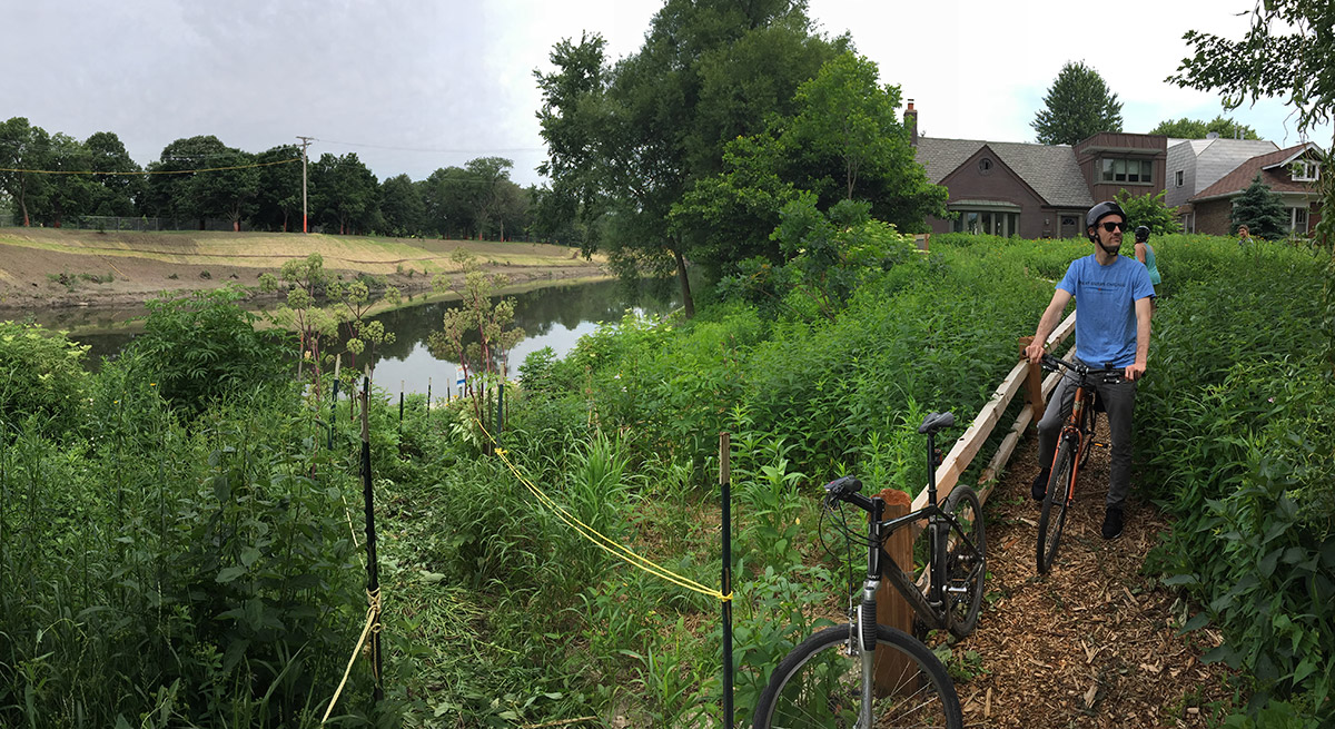
Riverbank neighbors steward the local riverbank through a partnership with MWRD, the Chicago Park District and Neighborspace.
As manufacturing in Chicago has evolved, moved, closed or cleaned up, residents and visitors have been pushing for a broader range of ways to use the river and riverbanks.
If you’ve been following Great Rivers Chicago and have basic knowledge of the history of Chicago’s rivers in general, you know that they are largely characterized as working rivers, manipulated and molded over time to serve the needs of the City That Works.
While Chicagoans have long recognized the incredible asset that Lake Michigan is—from fresh drinking water, to sandy beaches and continuous waterfront trails—the shoreline and water body have long been both locally and federally protected. As a city we have been slower to honor our river system because it has served us for a different purpose, yet that is rapidly changing.
Walk down to the Riverwalk on a summer day and you’ll see a heavily congested river, maxed with tour boats, water taxis, recreational vessels and kayaks. The Riverwalk offers entertainment, dining, bike rentals and plenty of people walking, jogging and enjoying the sunshine and architecture. Whereas in the past there was little interest in boating or recreating on the river, today it is easy to find an electric-powered boat or kayak to rent—both downtown and at one of the new boathouses on the North and South branches.
For the last 15 months, Great Rivers Chicago staff and partners have been learning from stakeholders—community members, local officials, business owners, environmentalists and technical experts—about how they currently think about the river and what aspirations they have for its future, while exploring strategies for achieving those ideas.
Through this outreach process, including a survey capturing the perspective of almost 5,000 people, we’ve learned that people here want to have a personal relationship with the river in locations north and south of downtown, close to their neighborhoods. They’re looking for a place to bring their family for a picnic, run/walk/bike, fish, read a book, dine or launch a boat. The survey and outreach revealed that in the future, they want the river to be clean and easy to get to, and provide active local destinations with park space.
In examining almost 155 miles of riverfront within the limits of the City of Chicago (including the Des Plaines River, Chicago River, North Branch, North Shore Channel, Sanitary and Ship Canal, Calumet River and Lake Calumet), we’ve learned that the character of the river changes frequently, from naturalized to residential to industrial.
Fostering a river that continues to be a major economic driver for the city as well as a recreation destination—cycling and walking, picnics, fishing, places to put your boat in and destinations to paddle it to—is a delicate balance. There are already many great places to do these things, but access to the river greatly depends on what stretch you’re trying to access.
The Chicago Park District and Dept. of Transportation have prioritized river trail improvements such as the North Branch Riverwalk and new parks and boat houses like those at Clark Park and Ping Tom Memorial Park—and, of course, the Riverwalk—which all encourage you to have a personal experience with the river, not just observe it from behind a fence. All of these spaces provide Chicagoans and visitors opportunities to experience the river and its banks in a way that best suits them.
Still, through the Great Rivers Chicago process, we’ve learned of Chicagoans who have taken matters into their own hands to create meaningful personal spaces, and communities that are working to create a local riverfront that is reflective of their residents’ desires.
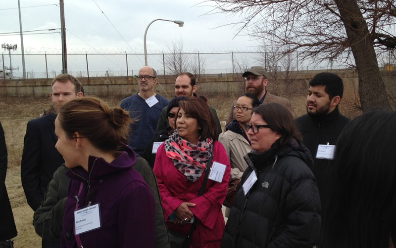
Community leaders and planners visit an underused site on Bubbly Creek to discuss possibilities for the future.
Community action
The Metropolitan Planning Council’s (MPC) placemaking work has taken us all over the region and nation to see firsthand how communities have transformed underperforming local spaces into vibrant community places. The Ravenswood community’s Riverbank Neighbors is a great source of inspiration in transforming riverfront stretches.
In 1993, residents of the Ravenswood neighborhood decided to take on the stewardship and maintenance of a strip of land owned by the Metropolitan Water Reclamation District that sits between the river and the residential community between Montrose and Berteau, describing it as a “dump” and “hiding place for rascals of all kinds.”
Seeking to change the dynamic of this riverfront, neighbors came together to remove invasive species, trim vines, pull weeds and build some basic infrastructure, such as steps that lead down to the river. A partnership was forged between NeighborSpace, an organization that fosters community-managed open space and holds liability for the land; the Chicago Park District; landowner Metropolitan Water Reclamation District; and Riverbank Neighbors, who maintain it.
Today, the riverbank is lush with native plants that help prevent the bank from erosion, while providing neighbors and visitors a beautiful and natural respite from busy Chicago life. Regularly planned potlucks, concerts and clean-up days keep the community engaged.
While the Ravenswood community was able to successfully take on the stewardship of their local river, other groups are still working on a solution to provide riverfront access to their communities. Because the character of the river changes as it traverses through communities, so do the local issues. Through Great Rivers Chicago, we have been working to address the complexities that limit quality access to the rivers in neighborhoods throughout the city.
Community access
On the far northwest side, access to the Des Plaines River is limited. A tangle of busy streets, along with poor bicycle and pedestrian access, is a deterrent. Yet the Des Plaines River serves as the connection between Chicago and neighboring suburbs.
On the Southwest Side, a former paint factory site along Bubbly Creek and Ashland Avenue could serve as a connection for the Pilsen and Bridgeport communities, as it is adjacent to the Orange Line and Canal Origins Park, and across from the new Park 571, which boasts a boat house designed by Jeanne Gang.
And in the Calumet area, cleaning up industry and providing more living wage jobs tops the list of priorities.
Case study: The Collateral Channel and Little Village
The riverfront in the Little Village area is mostly industrial in character and formerly home to the Crawford Coal Power Plant. Groups like the Little Village Environmental Justice Organization have been instrumental in addressing heavy-polluting industry and are looking for breaks in the industrial zones to provide residents access to the river.
The Collateral Channel, a small channel that heads directly north from this stretch of the Sanitary and Ship Canal, juts into Little Village and terminates on the south side of 31st Street across the street from La Villita, a new neighborhood park. There is no shortage of opportunities for this area of the city—a new park that could connect down through a quiet channel out to the river—yet the challenges are vast.
The Collateral Channel stretches a quarter mile north from the Sanitary and Ship canal to 31st Street in Little Village.
The Collateral Channel is a quarter mile long and approximately 100 feet wide. Because of sedimentation, it serves little purpose today, since it’s only a few feet deep in most areas. A combined sewer outfall pipe owned by the City of Chicago sits on the north end along 31st Street; the channel itself is owned by the Metropolitan Water Reclamation District.
The riverbed is contaminated and leaches methane gas, causing noxious odors to permeate the community, particularly in warmer seasons. While the land surrounding the channel offers immense opportunities for new recreation for the immediate community and for the City, the odor and environmental issues are immediate barriers to use.
“This is a public health concern and a quality of life issue,” notes Kim Wasserman-Nieto, organizing and strategy director at the Little Village Environmental Justice Organization. If the odor issue can’t be remediated, any new public access becomes worthless. The complexity of governmental players, cost and lack of a sound remediation strategy are major obstacles to overcome.
Great Rivers Chicago will produce a unifying vision and action agenda to guide future investments in Chicago’s rivers, yet there is not a one-size-fits-all approach. Our rivers connect our communities while revealing the unique character of each. While stretches of river are ripe opportunities for the next recreational frontier, we need to grapple with environmental concerns that impact surrounding communities, a menu of employment priorities in others, and a combination of both in most cases. Our report, to be released this summer, will lay out these complexities and propose ways to address these issues in order to maximize the potential of our City’s rivers.
« Back to stories