Banking on Success: Milwaukee's River Plan
October 27, 2015
, By MPC Director Josh Ellis and MPC Research Assistant Becky Clow
Flickr user Jeramey Jannene (CC)
Banking on Success offers insights into other cities' plans to reimagine their rivers and waterfronts. As Great Rivers Chicago works with residents and researches long-term priorities for the Chicago, Calumet and Des Plaines rivers in the city, these case studies offer examples of challenges, successes, and lessons for Chicago.
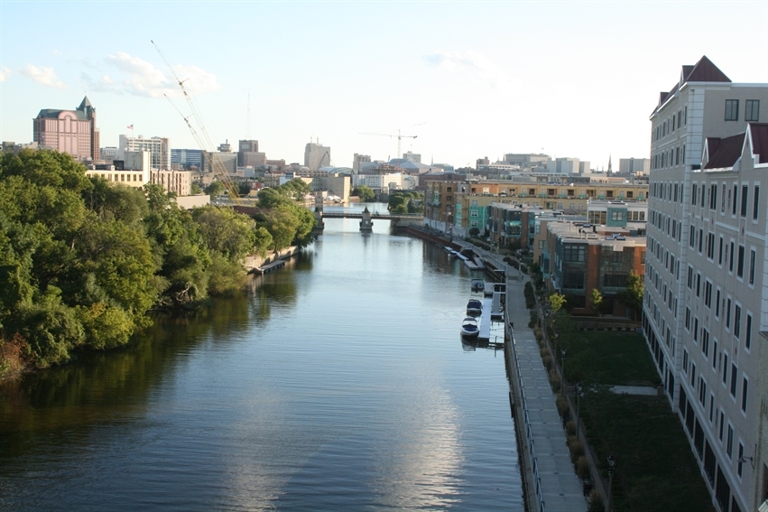
Like Chicago, Milwaukee, Wis. is located along the coast of Lake Michigan but also contains a major river, the Milwaukee. An important part of this city of roughly 600,000, the river flows through the north and terminates at Lake Michigan near downtown. The river provides ecological diversity and recreation as well as economic opportunities through transport and water resources. In recognition of the river’s importance, the Milwaukee River Work Group, a collaborative of stakeholders, created a river master plan in 2010 titled Milwaukee River Greenway Master Plan: A Vision for Recreation and Restoration.
Nuts and Bolts of the Plan
The Milwaukee river greenway is an ecologically diverse natural corridor surrounding seven miles of the Milwaukee River in the northeastern part of the city. It spans four local jurisdictions. The greenway provides a place for people to experience the outdoors within the urban landscape of Milwaukee. Before the 2010 master plan, the greenway contained a system of fragmented parks with recreational opportunities through biking and hiking trails. Even with these parks the greenway was fragmented and contained limited public access. The result was a disjointed system. The aim of the plan was to solve these issues by focusing on a shared use philosophy which strives to balance both recreational and ecological uses and needs.
The Milwaukee River Greenway Master Plan was conceived by the Milwaukee River Work Group, a collection of nonprofits, community members and government agencies, in 2008 to improve and shift the focus to the already in place greenway corridor. Previous efforts to protect the greenway corridor resulted in a great space for ecological diversity to thrive and sustainable community interaction with the river.
Prior to the plan the greenway was not being used to its full potential for recreational and natural purposes. In the master plan the work group wanted to provide ecological and recreational ways for the community to fully embrace the river again. The director of the Milwaukee River Work Group led the plan committee, composed of leaders from the work group. Topic-focused sub-committees composed of relevant stakeholders helped to complete the plan by providing ideas and feedback on topics such as trail use, easements, habitats and governance.
The Milwaukee River Greenway Master Plan outlines four major design principles or goals with specific implementation goals. The goals are outlined below:
Ecological Integrity
- develop quality and quantity recreation opportunities in the greenway
- improve and retain natural habitats
Stronger Links (trail system)
- create stronger links between the community, surrounding neighborhoods and the river
- provide places to enjoy the river while building a shared responsibility of the space
Imaging and Signage
- develop logo and signs that create a unified identity of the greenway
- provided sense of entry and arrival
- impart educational and interpretive information
- indicate warnings about sensitive or special places
- mark routes for wayfinding
High Protection Recreational Elements
- identify sensitive ecological resources and encourage corridor-wide ecological assessment and goal setting
- educate and inform users about natural areas
- develop sustainable recreational facilities with best management practices
Planning Process
This plan builds off of the improved water quality and ecological success of the removal of the North Avenue Dam in 1997 by focusing on providing more public access and recreation with the river and the riparian ecosystem. Before the removal of the dam, the river had poor water quality from the historic industrial uses of the river. The city ignored the riverfront for recreational purposes because of the poor water quality. The removal of the dam allowed the water to flow naturally along the river improving its overall quality. With the city’s new commitment to natural areas through the creation of the greenway and the removal of the dam, the plan will focus on improving the community’s connection to the river.
Throughout the planning process, the plan committee took many stakeholders’ and public comments and opinions into account. Many public informational meetings were held where the public could comment on the plan and the ideas presented within the plan. Stakeholder interviews were also conducted with specific leaders from neighborhood groups, public agencies, river focused institutions and private landowners to gather ideas for the plan as whole. More than 75 stakeholders were able to provide input on the plan through a half-day design workshop focused on the community’s needs around the topics natural habitats, neighborhood connections and recreation.
After reviewing the comments and suggestions made by stakeholders and the public, the Milwaukee River Work Group created a master plan focused on recreation and restoration, which included an action plan with a timeline. The work group separated the master plan into three main plans outlining the major concepts. The three sections include a habitat plan, a recreation plan and an action plan. Specifically, the action plan outlines a governance structure for the greenway, potential funding sources and tasks to be completed by specific groups. The final draft of the plan was completed in June of 2010.
Overall, the social and political feedback was generally positive about the greenway master plan. A survey conducted by the greenway working group showed that the public wanted quality outdoor recreation opportunities along the river corridor. This preference indicated a positive response to the plan’s focus on expanding the outdoor recreation opportunities by creating trails access points. Politically, two local aldermen took ownership of the plan and helped to navigate it through the local political process where the restrictions and approvals necessary for a successful plan were passed. The aldermen helped stakeholders realize that the plan had positive impacts for everyone, leading to a slow but positive political response.
After the Plan
The plan discusses that the Milwaukee River Greenway Coalition, formed from the plan working group, would lead the implementation of the plan. The plan outlined that the coalition would be a self-reliant, self-funded organization composed of local nonprofit and community leaders. Other local governments and organizations not a part of the coalition would provide recommendations to the coalition about implementation and funding. To remain self-funded the coalition would pursue private and public funding sources to cover the costs of a project administrator, an ecological assessment, design development, construction plans and ongoing management of the projects. Three years after the release of the plan in 2013, River Revitalization Foundation, a local land trust and one of the coalition’s founding members, became the new home of the coalition. Within the River Revitalization Foundation the Milwaukee River Greenway Director currently oversees the implementation of the plan along with collaboration from other coalition members and the Milwaukee County Parks.
After the release of the original plan, newsletters went out twice a year to provide updates on the progress of the plan implementation and news about the Milwaukee River Greenway Coalition. These newsletters continued for three years until the coalition was absorbed by the River Revitalization Foundation. Many projects working toward the goals and vision of the master plan were started before the plan was fully finished, providing a spring board for future plan projects.
Presently, some progress has been made in the implementation of the overall plan and vision presented in the plan. More specific pinpointed plans for signage, restoration and recreation are in the process of being completed to provide specifics for implementation of the ideas presented in the master plan. The signage plan has been completed and is being fully implemented by installing a variety of signs within and around the greenway. A habitat plan is currently being created with a wildlife biologist to outline the restoration and conservation work to be done in the corridor. Some habitat restoration is already underway, maintaining the natural spaces throughout the greenway. Along with these plans specific projects have also been completed along the greenway including increased accessibility through the building of parks, expanded trails, site cleanups and creation of the Rotary Centennial Arboretum. The coalition and City of Milwaukee are committed to preserving the greenway around the Milwaukee River while also providing recreational opportunities for the community.
Lessons for Chicago
Strengths
- focused on connecting the natural system of the river with the rest of the city and the people that live in the city
Weaknesses
- limited geographic scope encompassing only a small part of the city interacting with the river
Implementation Strategy
- focused on a vision and overarching ideas for the future as opposed to specific projects
- starting point for the creation of future more detailed plans and projects
Outcomes
- creation of topic-focused implementation plans after the release of the master plan
See what other cities we're studying.