Chicago residents have visions for their rivers
December 16, 2015
, By MPC Wayfinding Fellow Kelsey Pudlock
How often do you spend time at one of Chicago’s three rivers?
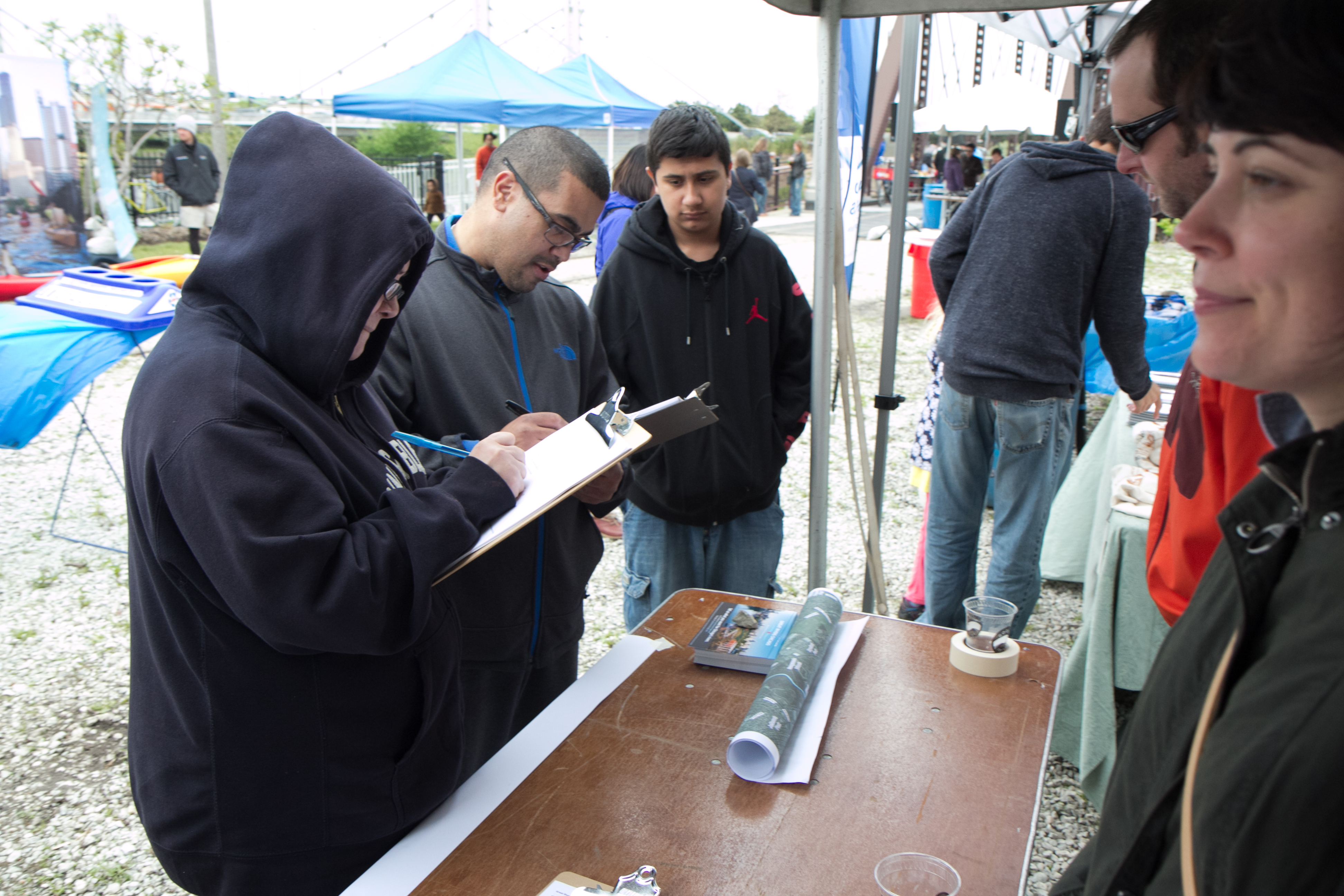
In spring of 2015, Great Rivers Chicago sent out an online survey asking Chicagoans to tell us what they think about our city’s rivers, and what they want to see in the future. We’re not just talking about the Chicago River, but also the Des Plaines and Calumet rivers that run along the northwest and southern stretches of the city, respectively.
Through our survey and a variety of public meetings, we received input from more than 5,000 Chicagoans. You can hear some of their ideas in this video created for us by the youth media makers at Free Spirit Media:
From May to July 2015, nearly 3,800 people took the survey. The results provided insights to how people view our rivers today and what they want to see in the future. The majority of the respondents lived within the city; however we also had a handful of respondents from the suburbs as well as few from out of state.
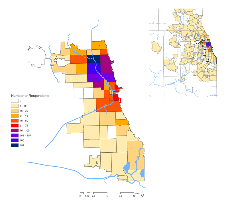
Number of respondents by zip codes within Chicago and surrounding region
There isn’t any one size fits all for Chicago’s river system; each stretch is drastically different for a variety of reasons. Because of that, we broke the river system out into six sections (shown below) and asked people to respond to questions about one section at a time.
The survey questions attempted to parse out how people interact (or don’t) with their chosen river segment: How do they perceive that area’s quality? Accessibility? Safety? Then we asked them to prioritize future uses. This gave respondents the opportunity to hone in on specifics and tell us what they think or feel about a particular stretch of the river. If they wanted to, respondents could then go back and pick a new segment of the river to respond on.
The majority of the respondents filled out the survey based on the area in which they lived—some went back and answered for another segment of the rivers, generally Area 3, Downtown. In total, there were 4,054 surveys across the six areas—with the north and main branches of the Chicago River garnering the most feedback.
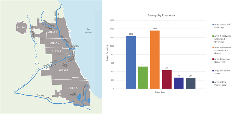
River areas (left) and number of survey by river area (right)
More than 50 percent of survey respondents live within a mile of the river, and more than 62 percent work a mile or less from the river. More than 52 percent of our respondents interact with the river on a weekly basis—30 percent of whom do so every day.
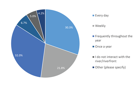
Frequency of interaction with Chicago's rivers
That may seem high, but “interacting with the river” is defined as “seeing or visiting the rivers/riverfronts for any reason,” whether that is via transit, work or recreation. The most common “river uses” were passing the rivers during a commute or going to parks or other public spaces near a river’s edge.
While there are some commonalities in people’s interactions across all six areas, how we get to the rivers, people’s overall perception of the rivers and their ideas for their future uses vary from segment to segment.
According to our survey results, people most often walk or bike to the river in Areas 1, 2 and 3; however, driving is the dominant mode in areas of the city characterized by low density and limited transit options—particularly the Des Plaines (Area 5) and Calumet (Area 6) regions.
We asked respondents to rate their overall feeling about the rivers, along with level of accessibility to the river/riverfront. Those in Area 4, which includes the South Branch of the Chicago River, Bubbly Creek and the Sanitary and Ship Canal, overwhelmingly ascribed ratings of poor and fair out of three possible choices (poor, fair and good). Here is what they think in more detail:
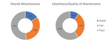
Respondents' ratings for Area 4
- More than 50 percent find the river to be unattractive and poorly maintained.
- Seventy percent find that river-related signage throughout the area is severely lacking.
- Approximately 40 percent believe the river’s visibility from a distance and accessibility via walking or biking is poor—with another 40 percent finding these qualities to be fair.
In other words, there is a strong connection between Area 4’s perception of quality and accessibility, and its sense of community and river-based uses. When we asked Area 4 respondents to rate the activities that take place along the river, more than 50 percent said the overall quality, mix, frequency and amount of activities that take place were poor, with only 13 to 15 percent of respondents rating them as good. The ratings for sense of community in this area followed nearly the same across the poor-fair-good spectrum. The only other part of the river system that has similar results is Area 5—the Calumet area, which includes Lake Calumet, parts of the Little and Grand Calumet rivers and the Cal-Sag Channel.
Area 5 also poses some insights into the people’s perception of the quality and uses that are unique to this segment of the river. When asked if the area of the river should accommodate manufacturing and shipping in the future, 61 percent of Area 5 respondents agreed and only 19 percent disagreed. Aside from 40 percent of Area 4’s respondents also agreeing that this use should be accommodate in the future, all other areas strongly disagreed—particularly Area 6, the Des Plaines River.
At the same time, 86 percent of Area 5 respondents agree that their river/riverfront area should be a thriving habitat for animals and plants, as well as flourish into active and vibrant places (where there are a variety of activities to draw them).
Despite the variability in the response across all six areas, all respondents used the same words to describe the future of their river segments. The top five words and phrases commonly used to describe the future were clean, active, easy to get to, parks and exercise. We believe these words set the framework of a shared vision for the future of our rivers.
As MPC heads into 2016, we will continue to strategize how rivers can become more accessible, accommodate jobs and support a wide range of uses, and ultimately determine how this vision can strategically be implemented throughout Chicago’s river system.