Banking on Success: Pittsburgh's riverfront transformation
December 14, 2015
, By MPC Director Josh Ellis and MPC Research Assistant Valerie Poulos
Flickr user Christian M. M. Brady (CC)
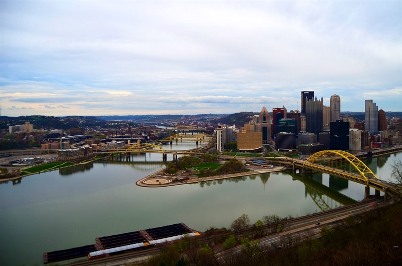
Pittsburgh's three rivers—the Ohio, Allegheny and Monongahela—converge downtown.
Banking on Success offers insights into other cities' plans to reimagine their rivers and waterfronts. As Great Rivers Chicago works with residents and researches long-term priorities for the Chicago, Calumet and Des Plaines rivers in the city, these case studies offer examples of challenges, successes, and lessons for Chicago.
Once nicknamed the “Gateway to the West,” the City of Pittsburgh and its rivers have undergone multiple fluctuations in identity, adapting to the ever-changing needs and demands of its people and the market.
Today Pittsburgh’s three rivers and respective riverfronts, the Ohio, Allegheny and Monongahela, are in the midst of another transformation, this time from an underused heavy industrial corridor to a space where shared living and recreation are taking precedence, helping citizens live the potential of their rivers.
To help accomplish this identity metamorphosis from the industrial rivers formerly known as the Rivers of Steel, to the confluence of the three rivers known as a new iconic gateway of Pittsburgh, A Vision Plan for Pittsburgh’s Riverfronts guided by Riverlife Task Force was drafted in 2001.
The Riverlife Task Force released the community plan to achieve a vision for the creation of an urban riverfront park system, the Three Rivers Park, serving as the center of a regional riverfront network. To date, more than 80 percent of the Three Rivers Park has been built, with more than 13 miles and 850 acres of publicly accessible riverfront parks and trails.
Nuts and Bolts of the Plan
The specific proposal of the Riverlife plan is to create, in the heart of Pittsburgh, an urban rivers park, Three Rivers Park, stretching along the three rivers. The boundaries of the park extend from the West End Bridge on the Ohio to the Sixteenth Street Bridge on the Allegheny and to the Tenth Street Bridge on the Monongahela.
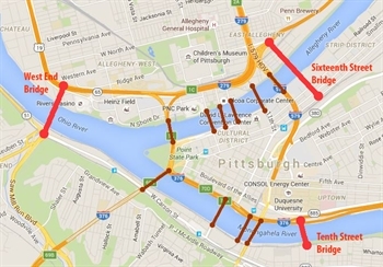
Three rivers park boundaries
Three Rivers Park was envisioned to be a continuous flow of trails, bridges, green space, and waterfront amenities. The backbone of the plan is to implement projects along the three rivers waterfronts connecting specific and strategic areas. For example, the Mon Wharf Switchback is a future project which will connect Pittsburgh's downtown area to the Mon Wharf Landing park and trail. The connecting ramp will be an ADA-accessible Switchback Ramp, providing a vital link for the Three Rivers Park.
The Riverlife plan consists of four parts: (I) Introduction and Vision, (II) Guiding Principles, (III) Advancing the Vision and Challenges Ahead and (IV) Components of the Three Rivers Park (projects). You can find all four parts of the Riverlife plan on their website.
The nine guiding principles for the Riverlife vision include:
- Organize riverfront investment.
- Reinforce the power of place.
- Enhance the shoreline experience.
- Increase connections to the rivers.
- Activate the water sheet.
- Celebrate the City of Bridges.
- Improve regional connections.
- Consolidate transportation.
- Incorporate the values of urban ecology and sustainability.
In 2001 the estimated budget for Three Rivers Park including the completed, underway and proposed projects was $90,450,000. The plan builds on projects that are already underway and leverages private and public investment. The planned and future projects hope to provide further connections to enhance the Three Rivers Park so that the whole is greater than its parts.
Planning Process
In 18 months, the Riverlife Task Force, now referred to as Riverlife, held more than 120 public meetings. The goal was to create a “desire line” to the river’s edge that would reflect the city’s diverse population. Each neighborhood and community along the river had its own opportunity to respond to the vision in order to ensure that the Three Rivers Park became the anchor for healthy urban diversification. Consequently, the six critical steps to achieve the vision include:
- Maintain a strong independent advocacy organization to avoid compromise.
- Determine the boundaries of Three Rivers Park and establish the principle of continuous public access to the water’s edge.
- Establish design standards and formal design review process for private investors and all development along the edges.
- Develop a fiscal strategy for raising capital, both for construction and for long-term maintenance and programming.
- Determine a management process for river uses: recreational, commercial and transportation.
- Establish a long-term schedule for implementation.
Challenges Faced
- The pace of development along the riverfront is always accelerating. Initially seen as a challenges, this pace allowed the vision to be tested and shaped in real time.
- The three rivers had never been seen or recognized holistically.
Challenges Ahead
- Champion the vision and insist that it not be compromised in execution.
- Coordinate development and operations of Three Rivers Park.
- Adopt common design standards to create high-quality public spaces.
- Collaborate with other entities for coordinated development of Three Rivers Park.
After the Plan
After the adoption of the plan, the goal to create a world-class riverfront is well on its way in Pittsburgh. The success of the Riverlife vision can be attributed to the coordination between established and underway riverfront projects and the Riverlife organization. The Riverlife website is an outstanding website that continues public outreach, and provides up-to-date information on the success of individual projects. The website works as an efficient tool, providing the essential link between individual riverfront projects and plans, and the Riverlife vision for the Three Rivers Park. To date, more than 80% of the Three Rivers Park has been built, with over 13 miles and 850 acres of publicly accessible riverfront parks and trails. In the future, Riverlife hopes to create new public open spaces along all three of the rivers and complete a downtown bike and pedestrian connection.
Major themes throughout projects:
- Illumination at access points and throughout trails
- Construction of new bridges and revitalization of old bridges
- Inclusion of pedestrian bridges
- Reorientation of neighborhoods toward (facing) the river
- Transformation of brownfield areas to future green spaces
Lessons for Chicago
After the Riverlife plan was released, implementation began to enhance the central portion of the city as a place to live. Realizing the complexity of the Three Rivers Park vision and goals, the plan was broken down into smaller parts (or plans). These smaller plans for individual riverfront projects are connected to the larger picture and are necessary to complete the overall vision. Similarly in Chicago, land use details for specific areas may eventually call for individual project plans. The wide view lens of the Riverlife plan narrows as it makes clearer observations and detailed plans and ensures successful implementation. Chicago can learn from this process and preemptively guide its growth within the larger Great Rivers Chicago vision and plan.
Additionally, it was of high priority for Pittsburgh to reimagine the role and character of its three rivers. This made it easier to physically begin the transformation of the riverfronts, incorporate new uses to achieve the vision, and plan for future river-use investment. In Chicago it’s also important to recognize the rivers’ key roles in history. Pittsburgh’s rivers transformed from strategic defense and economic power to intricately mixed public and private uses, civic and recreational purposes and work and dwelling places. Rethinking the roles of the Des Plaines, Chicago, and Calumet rivers can help visualize new uses and public interaction in the future.
Other lessons for Chicago:
- Recognize that boundaries can expand over time.
- Acknowledge that rezoning for private development may need to occur.
- Engage a balance of public and private investment and development incentives.
- Codify a system of urban elements and develop standards.
- Create practical strategies for maintenance and operations in the long-term.
- Understand the necessity of a fully flushed website that is constantly updated and linked with each individual project in order to measure success of implementation of the larger vision.
To see the transformation of Pittsburgh’s riverfronts, check out Riverlife’s before and after video.
See what other cities we're studying.